Exploring Tonty Canyon

Exploring Tonty Canyon

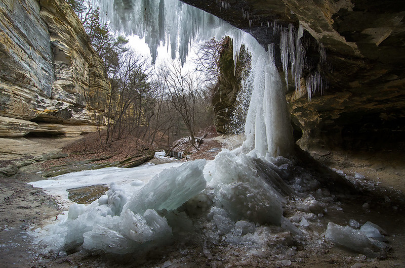
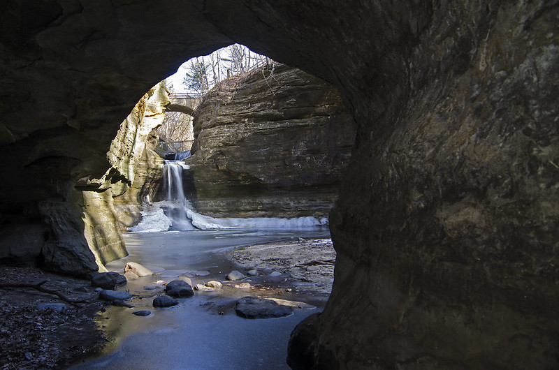
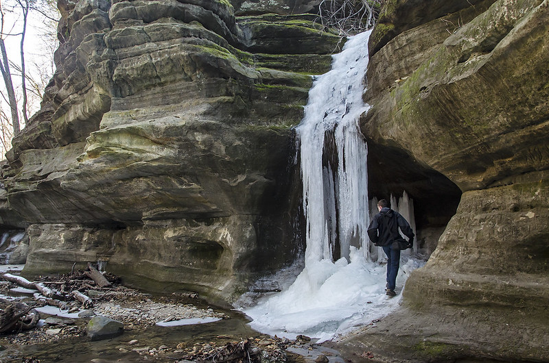
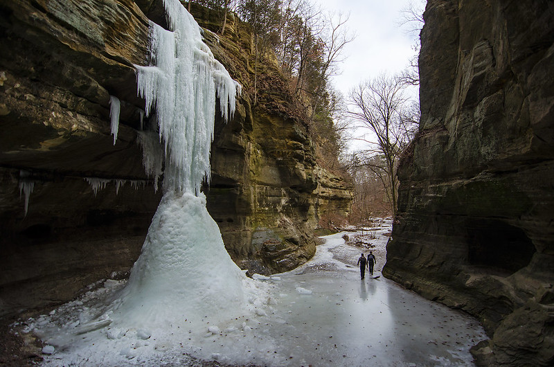
At approximately 60 feet in height, the frozen waterfall seen here is one of the two waterfalls found in Starved Rock State Park's Tonty Canyon. Following the often narrow trail that winds about 20 feet above the canyon floor can be a bit tricky in wet weather, but add ice, and it becomes dangerous. So much, that the trail was closed on one end, forcing us to walk to LaSalle Canyon first, just to double back to Tonty.  And of course, leaving the canyon meant doubling back again through LaSalle.

The two waterfalls were frozen, but this one in particular was more complete, and ornate in ice formations. The melting snow above fed the ice fall, and the below freezing temperatures helped build the ice falls.

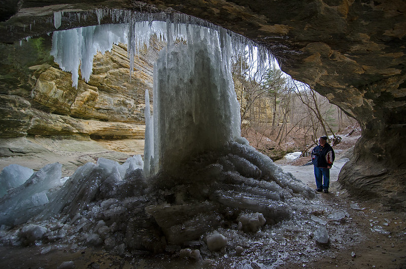
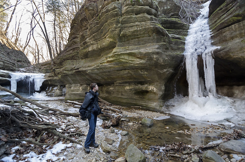
Ice climbing in Starved Rock is not unusual, and this is one of the ice falls I've seen people climb. Wildcat Canyon's 80 foot waterfall is a popular choice, as it's one of the closest falls to the visitor center and lodge. Luckily, were arrived before the falls became large and strong enough to climb; climbing often ruins the intricate formations on the falls.

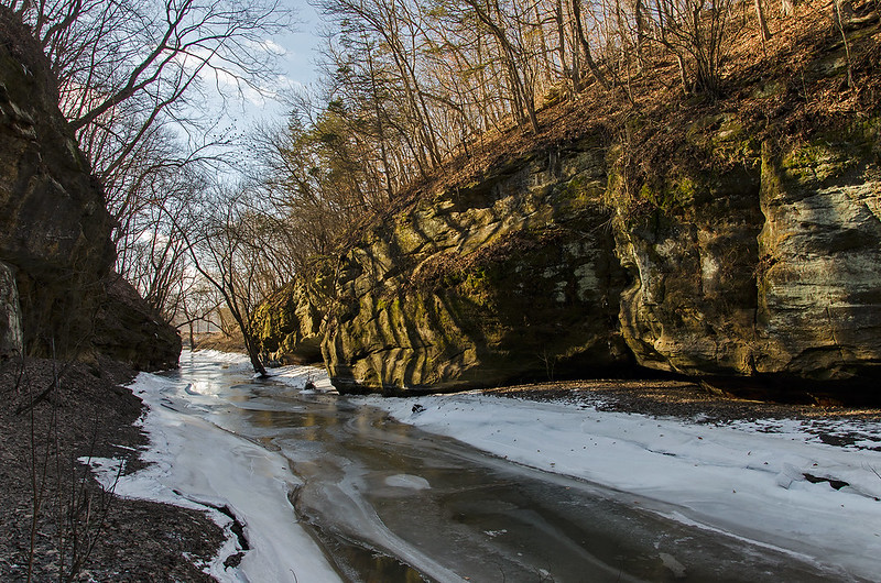
Most of the ice falls are hidden from passers by, and require a hike into the blind canyons.  They often reveal themselves dramatically after hikers round the last turn in the canyon, so the condition of the ice is never known until the last minute - but generally well worth the hike even if the ice has not formed.


Frozen Falls

Behind the Falls

Another look at the frozen waterfall in LaSalle Canyon, part of Starved Rock State Park in north central Illinois. The alternating warm/cold days added some dynamics to the ice formations that generally form in these canyons.

During the cold temperatures, the waterfalls froze, creating intricate pillars of ice clinging to the top of the rock outcroppings - much like stalactites. The water that dripped to the ground, gathered and froze, creating mounds of round ice - much like stalagmites. Eventually they join together to form a thick column of ice.

With the fluctuations in weather, the columns of ice have fallen to the ground in piles at the base of the falls. These chunks of ice measured about 4 feet in length and over a foot in diameter. The intricate patterns created by the dripping water made these columns appear like giant mineral crystals.

LaSalle Canyon is one of the few canyons in Starved Rock State Park where one can easily walk behind the waterfall - frozen or liquid.   In fact, the trail leads you under the outcropping. This provides a unique view of the canyon in any season. Many of the other falls can be accessed from behind if hikers don't mind crawling, climbing, or getting wet.

Looking past the waterfall, the expanse of the canyon comes into view; however, from this angle, one can only see about 1/8 of the length of the canyon. The walk to and from the falls can be just as interesting as the falls themselves.

Frozen Waterfall of LaSalle Canyon

Frozen Falls in LaSalle Canyon

Off and on cold weather creates and destroys beautiful ice falls formed by the waterfall in LaSalle Canyon.  Part of Illinois' Starved Rock State Park, the canyon is a bit of a hike from the visitor's center, but well worth the effort.

In wet times of year, a waterfall of approximately 20 feet tall flows into the canyon. In winter, the falling water freezes into intricate, and very large ice formations. The large undercut in the rock creates a shelter under the falling water, where visitors can hike. When frozen, the falls create an ice cave of sorts, giving hikers the opportunity to see the ice illuminated from behind.

The warming temperatures have broken some large chunks of ice away from the rock, but the cool overnight temperatures keep the ice growing from the top and bottom.


Winter View of the St. Joseph Range Lights

Winter View of the St. Joseph Range Lights

Taken on the beach, a bit farther away from the river, the shelf ice near the shore provides a bumpy foreground to the St. Joseph, Michigan lighthouses. Still forming, the shelf ice will eventually all but block the view of Lake Michigan and the lighthouses from the beach - unless, of course, you walk up the dune where you can see over the mounds.

I'm always amazed at the power of the lake - some of these ice chunks are almost three feet in diameter, and are found on the pier, and on top of 15 foot tall mounds. They were carried there by the waves during rough weather. Once deposited and frozen in place, they take on the look of a lunar landscape.

Closed for the winter, the north pier (where the lighthouses reside) attracts visitors viewing the ice build-up on the catwalk uprights. Probably closed because of the remodelling being done, some visitors ignore the fence and venture out anyway.  You can see two in this photo - they give some scale to the ice formations.

Most years, the ice forms all the way to the top of the outer lighthouse.  This hasn't really happened yet this year, but there's still time.

Bright Day on Lake Michigan

Bright Day on Lake Michigan

The bright winter sun illuminates the ice build up on the catwalk uprights, and the freshly painted lighthouse in St. Joseph, Michigan. Offset by the deep blue waters of Lake Michigan and the St. Joseph River, the beacon stands out in the winter landscape.

A favorite destination of ours each winter, the St. Joseph lighthouse hasn't collected as much ice as previous winters - yet.  As long as Lake Michigan remains liquid, and temperatures stay below freezing, there's a chance it could ice up once again.

The shelf ice is building along the beaches of Lake Michigan.  It appears the people visiting St. Joseph stayed off the ice (at least when I was there), while the people in South Haven ignored warnings and wandered onto the mounds of shelf ice a couple of hundred feet into Lake Michigan.

Here's why this is dangerous if not deadly: http://www.huffingtonpost.com/tom-gill/the-winter-shore-beautifu_b_6431724.html

Ice Balls at South Haven

Ice Balls at South Haven

January 2016 in Southwest Michigan, and the ice has finally begun to form along the lakeshore. While high winds and waves have not yet encrusted the lighthouses in ice, shelf ice is beginning to form on the beach and piers in South Haven.

The waves roll chunks of snow and ice together until round balls of ice form in the water.  A very similar process happens to rocks in rivers and oceans- they're tumbled against other rocks until the edges are smooth and round.  This is the same process, only much faster.

The chunks of ice we encountered today ranged from softball size all the way up to beach ball size - two feet in diameter.  These chunks float in Lake Michigan until the waves carry them up onto the beach, piers and shelf ice. This is the process that builds the mounds of shelf ice seen along the beaches of the Great Lakes. I've seen these chunks thrown up onto the 15 foot high shelf ice by the churning waters of Lake Michigan, some must weight a couple of hundred pounds.

A few more weeks of cold weather, and the shelf ice may extend hundreds of feet into the lake.  As tempting as it is to venture out onto the shelf ice, DON'T DO IT, it can be deadly. Read my Huffington Post article on the dangers of shelf ice: The Winter Shore: Beautiful but Potentially Deadly.

From Inside the Cave

From Inside The Cave

No trip to Illinois' Matthiessen State Park is complete without a hike through the lower dells; however, the water levels can rise too high to allow access to this area. Exploring the canyon's two waterfalls, and several small caves are the highlights.

At the far, blind end of the canyon, 45 foot tall Cascade Falls feeds the stream at the base of the canyon, and runs to the Vermilion River a few hundred meters away. Near the falls, some small caves dot the canyon walls, and most are large enough to walk into.  One in particular opens up to a great view of the falls.

Access to this part of the cave is a bit slippery in winter, but not dangerous. During high water periods, one must return to the original entrance, however in winter, the pond around the falls is frozen and walking on it is possible.

The stone walls are soft sandstone, easily carved by running water - and visitors throughout the decades. Names and even faces can be seen on the canyon walls, reminders of who visited before us.

To the Vermilion

To the Vermillion

A slight bit off the beaten path of Matthiessen State Park, lies this canyon leading to the Vermilion River. We attempted to hike to the river, but were not prepared to wade through the freezing water (and of course, did not want to wander off into unauthorized areas). The water level was a bit higher than normal, covering the trail a bit too much for winter weather. Looking closely at some of the trees near the stream, we could see evidence of much higher water levels not too long ago. Ice still clung to the trunks of the trees at the height of the previous freeze - about four feet higher than the level in this photo. More evidence of high water was seen elsewhere in the canyon, where a small wooden foot bridge was moved a couple of hundred meters away from its usual spot.

 The light in the canyon always interests me, but especially in winter. Such warm earth tones on the sunlit rock walls, in contrast to the cold ice and snow, combined with the shaded side that appears only in gray tones. Hiking and photographing the canyons gave us the impression it was much later in the day due to the shade of the steep canyon walls, even though our journey ended before lunch.

Dual Waterfalls

Dual Waterfalls

Exploring the canyon just beyond Cedar Point, we came upon two waterfalls which are familiar to us. A bit off the beaten path of Matthiessen Park, these waterfalls generally freeze up to create ice caves, and this process is beginning.

Only a few meters apart, both waterfalls can be viewed, explored, and photographed at once. We were between cold spells, so this particular morning was relatively warm - in the mid twenties, so while some water was freezing, the insides of the caves were still very liquid, and water poured in from all around.


Exploring the Ice Falls
While we couldn't explore all the way inside the caves, we did manage to get in to view the ice formations up close.

With the recent below zero weather, these falls should produce solid walls of ice very soon - and we'll head back.

Through the Cottonwoods

Through the Cottonwoods

Walking along the rim of the old quarry on a very cold afternoon, we spotted some old, and very large cottonwood trees.  We've been to this location numerous times, and never tire of the view through the trees.

The trees are on either side of a small creek that only runs during wet times, and their V formation seems to frame several interesting objects in the distance.  The quarry lake itself, now a popular place for fishing in summer and winter; a pile of cut stone left over from quarrying days; the steel bridge over the canal; and St. James of Sag Bridge church (seen on the hill in the distance).

I was surprised that we were the only people around the lake on this morning, and judging by the lack of footprints in the snow, for at least a day or two.  This lake is one of around 20 lakes in the Cook County Forest Preserve District that allow ice fishing, but I guess the ice just wasn't thick enough for any fishermen - which is surprising, since I've seen people on this lake in early December some years.

The Flocked Forest

Flocked Forest Trail

A wet snow fell overnight, then temperatures dropped into the single digits, freezing the snow on every branch of the trees at Waterfall Glen.  Some of the snow turned to ice, and shimmered in the light of the setting sun.

This was the beginning of our hike to the waterfall- an easy 1/4 mile or so, made all the more enjoyable by our surroundings. It's days like this I don't even notice the cold.

The waterfall is at the lowest part of the area, and was almost absent of snow on the trees, probably protected by the trees growing above the ridge. While the light and amount of snow near the falls were not as significant as I hoped, the walk to and from was inspiring.

Winter at Waterfall Glen

January at Waterfall Glen

Following a wet snowfall, temperatures in northern Illinois dropped to single digits; winter is here at last. The cold air made for a brisk hike to the waterfall, but the cold isn't even noticed until the walk back to the car, after the photos are taken.

If the temperatures stay below freezing for a bit longer, these falls will freeze up for the most part, creating interesting ice sculptures with water running beneath. Difficult to capture at this time of day, the ice covered branches of the trees shimmered in the sunlight. We were a bit late in the day for the sun to bathe this low-lying area, but our walk to the falls was beautiful.

Waterfall Glen is a popular destination for hiking, biking, and dog walking, and even on this cold day, the trails were covered in footprints. We encountered quite a few people as well - a stark contrast to our earlier stop at the now flooded Sag Quarries, where we were the first people to disturb the day-old snow.